


Byron Bay News
It’s final – Brunswick Heads goes underground


BROADWATER FERRY

Government adds to cost of living as buybacks begin

Farm Safety Shouldn’t Cost an Arm or a Leg

The annual Bizzy and Jomanda Brahman sale will be held Saturday 7th September 2024, 11am at the Grafton Saleyards.

Biosecurity System Reaps Rewards of Sensible Cost Recovery Reform

Are Your Workers in Safe Hands? The Critical Role of First Aid Training in Agriculture

A NEW TWEED HEADS

Toyota Supra: Get Ready For A Fully Electric Version In 2025

Northern Rivers Local Health District COVID-19 update

Northern Rivers COVID-19 update

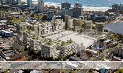
Fears proposed residential tower will ‘obliterate’ Tweed neighbourhood’s amenity and charm

COVID-19 Vaccination Clinic now open at Lismore Square


Two teens charged with property offences in Tamworth and Hunterview – Operation Regional Mongoose
Two teens charged with property offences in Tamworth and Hunterview – Operation Regional Mongoose Thursday, 25 July 2024 01:34:07 PM...
Two men arrested following Bondi police operation and pursuit
Two men arrested following Bondi police operation and pursuit Thursday, 25 July 2024 01:31:18 PM Two men have been arrested...
Man charged following incident at Miranda shopping centre – CTST Command
Man charged following incident at Miranda shopping centre – CTST Command Thursday, 25 July 2024 12:21:33 PM A man has...
-
 Tweed Shire News2 years ago
A NEW TWEED HEADS
-
 Motoring News1 year ago
Toyota Supra: Get Ready For A Fully Electric Version In 2025
-
 COVID-19 Northern Rivers News3 years ago
Northern Rivers Local Health District COVID-19 update
-
 COVID-19 Northern Rivers News3 years ago
Northern Rivers COVID-19 update
-
 Northern Rivers Local News3 years ago
Fears proposed residential tower will ‘obliterate’ Tweed neighbourhood’s amenity and charm
-
 Health News3 years ago
COVID-19 Vaccination Clinic now open at Lismore Square
-

 COVID-19 Northern Rivers News3 years ago
Lismore Family Medical Practice employee close contact
-

 NSW Breaking News3 years ago
Vale: Former NSW prison boss Ron Woodham