Connect with us
Byron Bay News and Weather copy
Mt Warning News and Weather copy
Kyogle News
Grafton News and Events copy
Byron Bay News and Weather copy
Mt Warning News and Weather copy
Kyogle News
Grafton News and Events copy
previous arrow
next arrow

Northern Rivers Local News

Oasis Park Development Halted

Published

on

By

Oasis Park plan
Advertisements
Care Connect Home Care Packages

Oasis Park Development Halted


Story by Lara Leahy


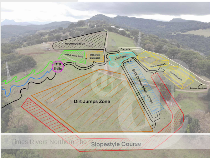
Plans were submitted for an extreme sports facility to be built at Carool to go with an existing DA for health retreat style accommodation.  Last week, Tweed Shire Council voted to refuse the Development Application for the park.


The initial DA for 35 cabins, and 5 rooms, also include a 4-bedroom site management house and attached granny flat has not yet been issued with a construction certificate.  The latest DA is for indoor and outdoor facilities for sports including motocross, mountain biking, skateboarding as well as gym and trampolining facilities spread over 18,902m2. Between the proposals, there was confusion as per the use of the facilities and how much would service the patrons vs public use.


There are 11 reasons council gave to turn the new development down.  Included in which is incomplete information on stormwater management, bushfire risk research as well as risk to potential existing indigenous heritage.  Inadequate infrastructure, such as sewerage, electricity, and car parking were also cited as concerns.


Issues regarding noise and light that would see up to 60 patrons visiting a day and up to 200 over 4 annual events were not addressed by the submission.  It was unclear how much of the clientele was to be from public use as opposed to visiting patrons.


A large concern was raised in regarding its visual amenity, with two large block sheds at the peak of the development, breaking up the sight lines of the surrounding hills.  The large amount of concrete, asphalt and exposed earthworks were also not considered to be in keeping with the “picturesque hills of Carool.”


One of the two sheds were over the height limit stipulated by council, causing interest for the airspace above the shed.  “The application was referred to the Gold Coast Airport Authority as the site has a ground level above the relevant Obstacle Limitation Surface Contour and therefore the development would breach this plane. The Gold Coast Airport Authority advised a full assessment would be required.”


Other incomplete information included traffic studies as well as flora and fauna impact contributing to the hesitancy to provide support for the development. Public concern was also considered when 18 of the 21 public responses received in regard to the development found to have objections to the proposal.


Two options were presented to council, to refuse the DA or to present them with an opportunity to provide further information.  Due to inconsistencies and inadequacies with the assessment of the works, council officers recommended the first option and refused the DA.  It was found that the “development proposal is not consistent with the Aims of Tweed Local Environmental Plan 2014 to promote the responsible sustainable management and conservation of Tweed’s natural and environmentally sensitive areas and waterways, visual amenity and scenic routes, built environment, and cultural heritage.”


The DA report and associated documentation is available on the Tweed Shire Council website.


Advertisements
Tenterfield-The Bowlo
Continue Reading

Ballina News

Understanding the impacts of overland flooding and stormwater in Ballina Shire

Published

on

By

Ballina Flooding Ballina News
Advertisements
Care Connect Home Care Packages

Understanding the impacts of overland flooding and stormwater in Ballina Shire


By Robert Heyward

To enhance community resilience, Ballina Shire Council is committed to better preparing the community to withstand the challenges and impacts of future flood events.

“This work involves conducting detailed flood mapping and modelling projects to better understand flooding, identify ways to minimise its impact, and incorporate effective mitigation strategies into the

region’s future plans,” said Paul Crozier, Manager Engineering Works at Ballina Shire Council.

“To enhance the accuracy of flood modelling across Ballina Shire, we are inviting the community to share descriptions and photos of observed overland flooding.”

“This includes detailed accounts from the March 2022 flood event to help refine and calibrate the models. Information from other significant rainfall events is also valuable and welcomed.”

Current public consultations are underway for several key studies in Ballina Shire, including the Ballina Island and West Ballina Local Stormwater Drainage Management Study and Stormwater Masterplan (SWMP), as well as the Alstonville, Wardell, and Lennox Head Overland Flood Studies.

These studies focus on overland flooding, which occurs when heavy rainfall exceeds the capacity of the drainage system, causing water to flow over land. This type of flooding commonly affects streets, yards, and low-lying areas where water accumulates and cannot drain quickly enough.

The SWMP and flood studies aim to:

  • Assess the current capacity of the stormwater drainage system.
  • Model and map overland flooding during various storm scenarios, including the significant March 2022 storm.
  • Pinpoint areas prone to flooding due to stormwater limitations.
  • Propose potential stormwater system upgrades to reduce future flooding risks.

Community members are invited to participate in an online survey from 20 November to 20 December 2024.

Details about the studies, along with the survey link, are available on the Council’s YourSay page.

Findings from the studies will be showcased in a public exhibition in 2025. The insights gathered will play a vital role in enhancing town planning, guiding future development, and improving emergency responses to future storm events.

These initiatives are funded by Ballina Shire Council in partnership with the NSW Department of Climate Change, Energy, the Environment and Water (DCCEEW).


For more local news, click here.

Advertisements
Tenterfield-The Bowlo
Continue Reading

Byron Bay News

New Koala Zones Aim to Protect Byron Shire’s Iconic Wildlife

Published

on

By

Koala Zones Byron Bay Sign
Advertisements
Care Connect Home Care Packages

New Koala Zones Aim to Protect Byron Shire’s Iconic Wildlife


By Robert Heyward

Byron Shire Council has introduced new Koala Zones on Broken Head Road, Coolamon Scenic Drive, and Coorabell Road near Federal, in an effort to reduce road strikes and protect local wildlife. These zones include vehicle-activated signs and painted road markings, encouraging drivers to slow down and stay alert for koalas and other native animals.

Why Koala Zones?

The selected roads are known hotspots for koalas, with multiple road strikes reported in these areas. Tragically, five koalas have been hit on Broken Head Road alone this year, including two beloved local males, “Moji” and “Braveheart.” The initiative aims to reduce these incidents and raise awareness among drivers.

“These areas are regularly used by koalas, and unfortunately, many have been killed by cars,” said Liz Caddick, Byron Shire Council’s Biodiversity Team Leader. “The new signs and road paint will remind drivers to slow down and look out for wildlife.”

How the Signs Work

The vehicle-activated signs are not speed cameras but serve as visual reminders:

  • Green happy face: Drivers traveling under 70 km/h.
  • Red sad face: Drivers exceeding the speed limit.
  • Speed display: Drivers approaching 80 km/h receive a speed reminder.

The signs, funded through the NSW Koala Strategy, are part of a four-year program to monitor the effects of these measures on driver behaviour and koala safety.

Community Collaboration

The project was developed in consultation with local wildlife carers from Bangalow Koalas and Friends of the Koala, ensuring the zones target areas with frequent koala activity.

Bangalow Koalas President, Linda Sparrow, praised the initiative:
“It’s heartbreaking to see koalas being hit. Slowing down on our roads, especially at dawn and dusk, can make a huge difference. These zones are a big step toward protecting our precious wildlife.”

Year-Round Vigilance Needed

While wildlife can appear at any time, koalas are especially active from June to December, during breeding season. Drivers are encouraged to stay vigilant and reduce speeds, even in built-up areas, as koalas often cannot escape oncoming vehicles in time.

Existing and Expanded Koala Zones

The new zones join existing ones on Mafeking Road and Bangalow Road, further extending efforts to create safer habitats for Byron Shire’s koala population.

If you see a sick or injured koala, contact Friends of the Koala at 6622 1233. The hotline operates 24/7 to provide urgent care.

By slowing down and staying alert, residents and visitors can help protect one of Australia’s most iconic species.


For more local news, click here.

Advertisements
Tenterfield-The Bowlo
Continue Reading

Lismore News

Growth Spurt for Lismore’s Community Gardens

Published

on

By

Lismore Community Garden Team with Greater Bank representatives
Advertisements
Care Connect Home Care Packages

Growth Spurt for Lismore’s Community Gardens


By Ian Rogers

Lismore’s beloved Community Garden, a hub of hope and healing in the wake of the 2022 floods, has received a much-needed boost through Greater Bank’s Northern Rivers Community Funding Program. The volunteer-led initiative, known for its lush produce and welcoming atmosphere, won the latest round of funding, aiding its mission to rejuvenate the gardens and nourish the community.

Rebuilding After the Floods

The floods devastated much of the garden’s infrastructure, including water tanks and solar panels. However, thanks to a dedicated group of 20 volunteers, the garden has slowly come back to life.

“Progress is slow, but our aim remains to nourish the community with food, socialising, and support,” said volunteer Rhonda. “The gardens also serve as a venue for community activities and gatherings.”

The volunteers also stock a ‘sharing table’ with fresh fruits, vegetables, and seedlings for locals to enjoy and grow in their own backyards.

A Community Effort

Greater Bank’s Regional Manager, Steph Smith, praised the volunteers for their dedication and highlighted the bank’s commitment to the region.

“Over the last three years, we’ve donated over $100,000 to groups in the Northern Rivers region, all working to improve our communities,” she said. “The volunteers at Lismore Community Garden are incredibly generous with their time and produce, and we’re thrilled to support their efforts.”

Rhonda also expressed her gratitude for the program’s impact.
“We rely on donations to keep the gardens sustainable, and we’re so grateful for this support,” she said. “It’s a wonderful program that lets our community have a say in where the funds go.”

Call for New Volunteers

With plenty of work still to do, the Community Garden welcomes new members to join their team of volunteers. The group tends to the garden on Wednesday and Saturday mornings, though the space is always open for the public to enjoy.

Next Funding Round

The November round of the #GreaterNorthernRivers Community Funding Program offers another $3,000 in funding, with entrants including Lismore Preschool Incorporated, CFD Foundation Henry James Fund, and Ballina Little Athletics Inc.

For more information or to support the Lismore Community Garden, stop by on a volunteer day or connect through the garden’s community events.


For more local news, click here.

Advertisements
Tenterfield-The Bowlo
Continue Reading

NRTimes Online

National News Australia

Facebook

Latest News

Verified by MonsterInsights